


Nalbari District Profile
The District (Nalbari) Scenario:
The Historical background of the Nalbari District is well known to the people all over the States. Nalbari it has developed into a multi-lingual settlement ideal for administration, educational and ecclesiastical expansion. In this brief paper , I have tried to identify firstly the process of urbanization that took place over the last hundred years, which gave the town a cosmopolitan outlook. Secondly, I have mapped out a brief sketch of the town of Nalbari, with various social groups whose languages play an important role in the lives of the town. Thirdly I have found that urban ethnic groups have their distinct settlements in different parts of the town, which adds to the mosaic of this social fabric. At the end of this paper reports on the ethnic and linguistic complexity of this town, which gives in a dist character. Urbanization refers to the movement of population that resides in urban areas, and the resulting increase in population from rural areas. Urbanization means the movement of people from village to town and the effect of this movement upon the migrants and their families and upon their fellowmen in the villages. Urbanization may be defined, as a process of concentration of non-agricultural occupations and land uses around a single nucleus or multiple nuclei.
The settlements thus, emerging create a distinctive physical and social environment different from the adjourning regions. It provides contrasts in terms of occupations, socio-economic value systems, way of life, degrees of social-economic awakening and level of social and economic interaction. The study of the processes of urbanization and urban growth thus, is primarily concerned with the recognition and analysis of the basis economic and sociological factors that are responsible for the physical growth of settlement to an urban centre. The dynamics of urbanization, however, is complex one. The natural increase of existing urban population add to total number of people on one hand and the people from adjoining regions tend to concrete to already crowded clusters , on the other hand, the concentration of population in such clusters is guided both by push factors in the adjoining regions and pull factors operating in the urban centers. Thus, urbanization refers to the movement of people from the rural areas leading to the process of change in values, attitudes and styles of those people, who migrate to cities and towns from villages.
Ethnic composition:
Nalbari is a district where different religious people mainly Hindus, Muslim, Christians, Jains and Animistic ( tribal religion) . The different ethnic groups have been practicing their own religious activities peacefully . The concept of ethnicity helps in understanding the heterogeneity of population. If ethnic loyalties are acquired by birth, they are called primordial. Punekar thinks that ethnicity is “ the sense of people hood or we feeling shared by members of a group. It is in the town that we find various groups based on ethnicity.
Ethnic Settlements:
The population composition of Nalbari town is ethnically dominated by the Assamese , Bodo, Bengali, Nepali, Hindustani ( people outside Assam). Linguistic uniformity brought greater harmony amongst the different ethnic groups who used to differ not only in their spoken languages, but also in their administrative organizations, customary lows, and social and societal institutions. Such harmony as is expected, has been at work positively in the growth of Nalbari despite the fact, that different group maintains their identities . Inter-ethnic relationship within the town generally appears to be harmonious not only in the economic field, but also in social context. Various ethnic groups are almost equally important as a business communities in matters of business dealings. Any such apprehension is further thwarted by the fact that social interaction between different ethnic groups with regard especially to marriage is very common.
INTRODUCTION:
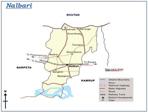
Nalbari District is situated in between Kamrup and Barpeta District. For better administration, old Kamrup District has been divided into three Districts. Nalbari was declared a sub division of undivided Kamrup District in 1967. Rajendra Mohan Goswami, ACS was first Sub Divisional Officer in Nalbari. Nalbari Sub Division is formally declared as a District in 14th August,1985.Shri V.K. Pipersenia, IAS, was first Deputy Commissioner in Nalbari.
A. GENERAL INFORMATION:
1. Geographical Location:
The Nalbari District is situated in between 26oN and 27o N latitude and 91o E and 97o E longitude . The northern side of the district is bounded by the Indo-Bhutan International boundary and the southern side by the mighty Brahmaputra. The Darrang and the Kamrup District falls in the east and the Barpeta District in the west. The Nalbari District stands covering an area of 999.90 sq.km. consisting of 1(one) Civil Sub-Division, 8 no.Revenue Circle, 8no. Community Development Blocks, 6no. Police Stations,7no. Anchalik Panchayats and 65 no. Gaon Panchayats covering 471 villages
2. Area and Administrative Division:
3. Physical features
The entire area of the District is situated at the plans of the Brahmaputra Valley. The tributaries of the Brahmaputra, Nona, Buradia, Pagaldia, Borolia and Tihu which are originated from the foothills of the Himalayan Range are wild in nature and have enormous contribution towards the agrarian economy of the district.
4. Soil
The Soil condition of District is a heterogeneous one. The Soil of the northern part of the district is clayey and loamy where as middle part is loamy and sandy. The Soil of the southern part of the district is composed of sandy soil.
5. Climate & Rainfalll
The District has a sub-tropical climate with semi – dry hot summer and cold winter. During summer, generally during the months from May to August, heavy rainfall occurs for which the district experiences flood. The District experiences annual (average) rainfall and humidity @ 1500 mm and @ 80 % respectively.
B. POPULATION (As per Census of undivided Nalbari):
1. Population :
Accordingly to 2001 census, the populations of the District is 1138184 Again, according to size of population, the rank of the District stands at 10th (2001 census) as against 9th in 1991.
2.Child population:
As per 2001 Census, out of the total population of the district ( 1138184),161616 are children belongs to the age group 0-6 years and accounts for 14.20% of the total population of the district. According to the size of children population, the rank of the district degraded to the 12th position among the 23 civil district of the State as against the 8th position in 1991 with 189113 children. Thus, the percentage trend in 2001 ( -14.54 ) over the child population figure of 1991.
3.Density :
The District with 2.88% area of the State shelters about 4.27 % of the States total population as per 2001 census. The density per sq. km. In the District is 504 persons an against 340 persons per sq. km. For the whole State. The density per sq. km. In the district , as per 1991 census was 450 as against 286 persons for the State as a whole. The density per sq. km. For urban area is calculated as 1977 an for rural area as 495 as per 2001 census as against 1689 and 443 persons in respect of rural areas and 1689 persons in urban areas.
4.Rural and Urban composition:
The district has a total of 1110706 rural and 27478 urban population as per 2001 census. Thus, nearly 97.59% of the total populations of the district live in villages. As per 1991 census, the figure of rural and ur5ban populations of the district were 992915 and 23475 respectively. Thus, the percentage of decadal growth (1991-2001) of rural and urban population of the district are calculated as (+) 36.24 of the State as a whole. In respect of child population (0-6) years age group), 98.19 % live in rural area and 1.81 in urban area as per 2001 census.
5.Population of SCs & STs :
The Scheduled Castes and Scheduled Tribes population details has not been published by the Census Authority till preparation of this report . However, as per 1991 census, the Scheduled Castes and Scheduled Tribe population of the Nalbari District was 89194 and 179641 respectively constitution of 8.78% and 17.67% of the total population of the District. The Scheduled Caste and Scheduled Tribe population together account for 26.45 % of the District’s total population which was much higher than that of state figure of 20.23 %.
6.Literacy :
As per 2001 census, out of the total population (1138184).664886 persons are declared literate. In 1991, the figure of literate was 463162 and as such percentage of literates increased by 43.55 in 2001 over 1991. The rate of total literacy of Nalbari District, according to 2001 census, is 68.08 as against 33.99 in 1991. Thus, the decadal (1991-2001) progress of literacy rate is calculated as (+) 12.09. The total literacy rate of the State as a whole (64.28 : 2001 census ). As per 2001 census, the rate of literacy in rural area of the district in rural area is 67.55 and in urban area is 88.61 as against 55.38 and 80.62 respectively in 1991.
7 No. of Occupied Residential Houses:
As per 1991 census, the rural areas of the District have a total of 160803 occupied residential houses with 160804 households. In respect of the urban area of the District, there are 4138 residential houses and 4138 households.
How to reach :
Road links to Nalbari is through National Highway 31 and Broadgauge Line. Nalbari town is 2 Km away from the National Highway 31. Nearest Railway Junction is Rangia. Nalbari Town is 60 Km away from Guwahati Bus Stand.
By Bus
1. From Guwahati : Avail any delux bus or auto to Adabari Public Bus Stand and from there take any Nalbari Bounded Bus and get down in Nalbari Town.
2. From L.G.B. Airport, Borjhar Guwahati: Avail a taxi to Adabari Bus Stand from there take any Nalbari Bounded Bus.
By Train
From Paltan Bazar Railway Station avail any Train and get down in Nalbari Railway Station. Major Trains are Kamrup Express ( Starts at 7 am ), Brahmaputra Mail( Starts at 12-30 am), Inter-city Bangaigaon Express (Starts at 5-15 pm ) Chifung Mail (Starts at 3-15 pm ) . Train takes maximum 2 hours to reach Nalbari.
Occupational Pattern :
The occupational distribution of the people in the district is not satisfactory. About 62.99% of the rural populations are cultivators and about 75.26 of the rural people depend on agriculture.
Out of total population about 7% are landless, 4% re marginal landholder, 31% are small land holders and 21% are big land holder.
Live Stock :
|
Forest / Fisheries |
1.57% |
|
Mining & Queering |
.006% |
|
Household industries |
2.01% |
|
Manufacturing |
2.91% |
|
Construction |
1.25% |
|
Trade & Commerce |
5.52% |
|
Transport & Communication |
1.09% |
|
Other services |
10.35% |
Industry :
Nalbari District is industrially very backward. There is no heavy industry. There are only three medium size industries. One Polyester Fabric production industry at present sick. Small industries like Handloom are found mainly in rural areas, specially in tribal areas. Sericulture is also an important subsidiary occupation of the tribal . There are some weaving enters also. Nalbari is famous for cane and bamboo product. These products are exported all over the state as well as outside that state also.
Nalbari District at a Glance (After Division)
|
Basic Information |
|
|
Area in Sq Km. |
999.90 |
|
Latitude |
26oN and 27o N |
|
Longitude |
91o E and 97o E |
|
Total Population( Census 2001) Divided |
6,71,940 |
|
Length of National High Way |
38 Km |
|
Length of PWD Roads |
1582 km |
|
Length of Gravel Road |
1041.12 km |
|
No of Sub Division |
1 |
|
No of Revenue Circle |
8 |
|
No of CD Block |
8 |
|
No of Education Block |
5 |
|
No of CIC |
12 |
|
No of Town |
2 |
|
No of Gaon Panchayat |
65 |
|
No of Zila Parishad Constituency |
23 |
|
No of Anchalik Panchayat Constituency |
7 |
|
No of LAC |
3 |
|
No of HPC |
4 |
|
No of BSS |
37 |
|
No of K. Oil Depot |
16 |
|
No of Villages ( Divided) |
471 |
|
No of Police Station |
6 |
|
No of Police outpost |
10 |
|
No of Tea Garden |
3 |
|
No of Commercial Bank |
25 |
|
No of Rural Bank |
24 |
|
No of Cooperative Bank |
5 |
|
No of Head post Office |
1 |
|
No of Post Office |
37 |
|
No of Sub Post Office |
204 |
|
No of Fire Station |
3 |
|
|
|
|
Occupational Profile |
|
|
State Govt Employee |
16,160 |
|
Central Govt Employee |
1,423 |
|
State Semi Govt Employe |
771 |
|
Central Semi Govt Employee |
609 |
|
Local bodies Employee |
140 |
|
Cultivators |
1,34,043 |
|
Agri Labour |
49,552 |
|
Other Industries |
12,350 |
|
Trade & Commerce |
17,659 |
|
Others |
1,05,723 |
|
Total Main Workers |
3,19,327 |
|
No of Unemployed Youth registered (As on 31-12-2000) |
78,790 |
|
|
|
|
Health |
|
|
Civil Hospital |
1 |
|
Block Public Health Center |
7 |
|
Mini Public Health Center |
30 |
|
Community Health Center |
5 |
|
State Dispensaries |
14 |
|
Health Sub Center |
217 |
|
|
|
|
Major Rivers |
|
|
1. Brahmaputra |
|
|
2. Mara Pagaldia |
|
|
3. Burhadia |
|
|
4. Nona |
|
|
5.Tihu River |
|
Local Newspaper Published From Nalbari |
|
1) Louit Jyoti (Weekly) |
|
|
|
Hotel for Accommodation |
|
1.Hotel Premoda |
|
2.Hotel Gayatri |
|
3.Hotel Bardoishila |
|
4.Abhilash Lodge, |
|
|
|
Yoga and Meditation Centre |
|
1.Rajyoga Education Centre |
|
2. Anandapuram Yoga Institute |
EDUCATION:
Number of primary and middle schools, enrolment and teachers, 2010-11:
|
Particulars |
Nalbari |
Assam |
||
|
No. of Primary School |
884 |
35065 |
||
|
No. of Middle School |
Govt./Provincialized |
Primary with UP |
39 |
941 |
|
Upper Primary |
115 |
4908 |
||
|
Composite |
73 |
1462 |
||
|
Recognized |
Upper Primary |
131 |
5397 |
|
|
Composite |
6 |
277 |
||
|
Total |
364 |
12985 |
||
|
Primary |
Enrolment |
Female |
77874 |
1279368 |
|
Total |
153639 |
2655582 |
||
|
Teachers |
Female |
902 |
30340 |
|
|
Total |
2607 |
81554 |
||
|
Middle |
Enrolment |
Female |
69988 |
1110913 |
|
Total |
132280 |
2156110 |
||
|
Teachers |
Female |
313 |
9675 |
|
|
Total |
3150 |
100477 |
Source: Statistical Handbook Assam 2009
Number of high, higher secondary schools and junior colleges, enrolment and teachers, 2010-11:
|
Particulars |
Nalbari |
Assam |
||
|
High School |
No. of Institutions |
194 |
5714 |
|
|
Enrolment |
Female |
10550 |
301754 |
|
|
Total |
27350 |
663722 |
||
|
Teachers |
Female |
741 |
16809 |
|
|
Total |
1633 |
62175 |
||
|
Higher Secondary |
No. of Institutions |
46 |
933 |
|
|
Enrolment |
Female |
12750 |
79143 |
|
|
Total |
29660 |
188309 |
||
|
Teachers |
Female |
131 |
5481 |
|
|
Total |
305 |
16346 |
||
|
Junior College |
No. of Institutions |
21 |
218 |
|
|
Enrolment |
Female |
6080 |
25447 |
|
|
Total |
15100 |
58855 |
||
|
Teachers |
Female |
90 |
992 |
|
|
Total |
245 |
2913 |
||
Source: Statistical Handbook Assam 2009
Status of classrooms in Govt. / Provincialized primary and upper primary schools:
|
District / State |
*No. of Primary Schools |
No. of classrooms in Primary Schools |
**No. of Upper Primary Schools |
No. of classrooms in U.P.S. |
Average Student Class-room ratio |
Pupil Teacher ratio (PTR) |
||
|
Primary |
Upper Primary |
Primary |
Upper Primary |
|||||
|
Nalbari |
834 |
2622 |
154 |
702 |
16.94 |
25.01 |
18.6 |
13.1 |
|
Assam |
30050 |
86150 |
5849 |
24412 |
25.09 |
37.15 |
30.7 |
21.3 |
* 5015 upgraded EGS to Primary Schools are not considered.
** Upper Primary Schools having primary classes are taken as Primary
Government and provincialized primary & upper primary schools having various facilities, 2010-11:
|
District / State |
Primary School |
Middle School |
||||||
|
No. of Schools |
Drinking Water |
Common Toilet |
Girls Toilet |
No. of Schools |
Drinking Water |
Common Toilet |
Girls Toilet |
|
|
Nalbari |
834 |
812 |
768 |
264 |
154 |
150 |
137 |
94 |
|
Assam |
30050 |
27026 |
20953 |
15110 |
5849 |
5316 |
4298 |
4340 |
Source: DISE, 2011-12
DEMOGRAPHY:
Demographic profile, 2011 Census:
|
District |
Area in Sq. Km. |
Population |
Male |
Female |
Rural |
Urban |
Population Density per Sq. Km. |
|
Nalbari |
1009.57 |
769919 |
395804 |
374115 |
687368 |
82551 |
763 |
|
Assam |
78438.08 |
31169272 |
15954927 |
15214345 |
26780516 |
44388756 |
397 |
Comparative population statistics:
|
District |
Population 2001 |
Population 2011 |
Sex Ratio |
Decadal Growth Rate (%) |
||||||
|
Total |
Male |
Female |
Total |
Male |
Female |
2001 |
2011 |
1991-01 |
2001-11 |
|
|
*Nalbari |
689053 |
356730 |
332323 |
769919 |
395804 |
374115 |
932 |
945 |
14.21 |
11.74 |
|
Assam |
26655528 |
13777037 |
12878491 |
31169272 |
15954927 |
15214345 |
935 |
954 |
18.92 |
16.93 |
Source: DISE, 2011-12
*Due to creation of new 4 districts the rates for 2001 have been affected in 12 districts
Literacy rate by sex:
|
District |
Person |
Male |
Female |
|||
|
2001 |
2011 |
2001 |
2011 |
2001 |
2011 |
|
|
Nalbari |
72.66 |
79.89 |
80.95 |
85.58 |
63.71 |
73.85 |
|
Assam |
63.25 |
73.18 |
71.28 |
78.81 |
54.61 |
67.27 |
District Border:
|
East |
Kamrup District |
|
West |
Barpeta District |
|
North |
Bhutan |
|
South |
River Bramhaputra |